| Start Point | Rifugio Pian dell’Arma |
| Arrival Point | Rifugio Pian dell’Arma |
| Length about | circa 5,6 km |
| Difficulty | Easy |
| Height difference | +1.624 / -1.334 m |
| Recommended period | Spring and Autumn |
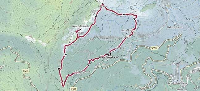
Source: Outdooractive.com
Upstream of the Rifugio there is a path (indication Baby Trekking) which enters a wooded area and soon reaches a crossroads. You can continue on a branch to the right and after a long uphill stretch, join the path coming from Colle di Caprauna.
Go right (white-red AVML trail), and ignoring the stretch that goes down to Ormea,
continue straight ahead in the wooded area until you reach a rocky stretch.
Go around it to the right to then pass under an asperity, near a repeater panel, from the top of which you can enjoy a beautiful panorama of the Ligurian Alps.
The path continues along the hillside, with a beautiful route between coniferous trees and shrubs, until it crosses the detour for Monte della Guardia (palina).
Then go up to the left, following the trail indicated by sparse “red stamps”, and after a short climb you can arrive on the panoramic summit ridge. On the right stands a large memorial stone while on the left, with a further up and down path, you reach the actual summit of Monte della Guardia, surmounted by the summit cross (1658m). The panorama extends over the Tanaro valley and, on the opposite side, over the Pennavaira valley and the Ligurian coast.
Curiosity: here you can toast with a bottle of sparkling wine that the CAI members of Asti keep in a cellar placed next to the cross.
Going back down to the crossroads for the detour on the AVML, you can continue on a nice little path which, after a stretch in the pine forest, which leads to the large Colla Bassa depression at the beginning of a vast pasture area.
Leave the continuation of the itinerary that leads to Monte Armetta, which stands out in the background, to turn right on a detour that allows you to return to the Rifugio Pian dell’Arma (palina).
After a downhill stretch, when you arrive at an isolated house, briefly follow a dirt road to the right and then leave it and continue to descend continuously and then enter a wooded area. The path gradually loses altitude with a series of turns, and then continues alternating long ups and downs. At the crossroads, turn right and you will soon arrive at the Rifugio Pian dell’Arma.
Source: Trekking.blogspot.com