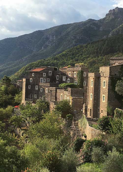
The name of Castelbianco is undoubtedly to be connected with some peculiarity of the castle that once
stood on the promontory, (the ruins of which can be seen today) but no official documents have ever been found in this regard.
The castle was small in size and it was in direct visual contact with that of Alto (CN) – now in the Piemonte region.
In addition to being a lookout and signaling spot to prevent hostile attacks, it served to collect taxes and
control the traffic of merchants who shuttled between the sea areas and the Piedmonte-Padania territories.
One of the earliest documents in which there is mention of Castelbianco’s name is dated to 1202.
There it is reported that it was owned by the Marquis Clavesana. Later in 1270 the Albenga people conquered it. It was then recaptured by Marquis Emanuele I of Clavesana in 1288 and later became a fief of the Marquis Del Carretto of Finale. Subsequently Castelbianco became part of the new branch of the Marquises Del Carretto of Zuccarello, who seceded from Finale.
In 1588 Carlo Emanuele I Duke of Savoy attempted to purchase the marquisate but encountered resistance from Genoa. In 1624 Genoa acquired part of the marquisate, and in the following year the Franco-Piemontese invasion of Western Liguria took place with the occupation of the marquisate.
In 1795 the town was involved in the French invasion that culminated in the Battle of Loano. With the unification of Italy in 1861, the territory “returned” to the Province of Genoa and this was until 1927, when it started to depend on the new province of Savona.
The municipality currently consists of four fractions; [Veravo (the Main Town), Vesallo, Oresine and Colletta], all are located “halfway up the coast” surrounded by cherry and olive tree groves that form silvery green patches; on the other hand the few groups of houses located on the valley floor have sprung up around old mills, olive presses and mallets.
Castelbianco belongs to the Province of Savona, and is located in Ponente Ligure, in the direct hinterland of Albenga. It covers 14.76 km2, bordering the municipality of Vendone to the south, the municipality of Nasino to the north – west, the municipality of Erli to the north, Zuccarello to the east, and Arnasco to the south – east. The minimum and maximum altitude of the municipal territory is 140 meters above sea level and 1141 meters above sea level, respectively.
Around the mid-1800s Castelbianco reached its greatest population development. Later, in 1887, the town, and Colletta in particular, was hit by a violent earthquake that resulted in the gradual abandonment of the hamlet. Together with the population exodus from the countryside to the cities typical of the post-war period for all inland towns, the earthquake led the village to its lowest population records in the last decades of the last century.
Thankfully for some years now, thanks to the admirable recovery of the Colletta hamlet (study and project by architect Giancarlo De Carlo) – known internationally as the “First Italian Telematic Village” – and the policies of local development put in place by the administration, the town shows a substantial inverse trend, with a steady growth of residents.
Source: Castelbianco.it